
Saṃsāra · public governance · witnessed
Bhandara Water Watch.
Bhandara district · eastern Maharashtra, India · the Wainganga basin
Where should the district build its next check dams, percolation tanks and gully plugs — and which of its old malguzari tanks are worth desilting first? We answer it from the terrain itself: every candidate is sited on the real drainage network, screened against slope, land use and catchment, and ranked by where storage is genuinely missing.
- District area
- 4,222.8 km²
- Elevation
- 206–535.1 m
- Dominant soil
- HSG-D
- Runoff (80 mm)
- CN 89 · 51 mm
- Candidate sites
- 57
For the administration
Executive summary.
The whole study in one view — what was found, what it would deliver, and what to do next. Every figure below is read from the witnessed data on this page and is reproducible from scripts/water/.
- · What this is. A research-grade, satellite-witnessed siting study for Bhandara’s water conservation — where to build new check dams, percolation tanks and gully plugs, and which old malguzari tanks to desilt first. Every one of the 57 candidates sits on the real 30 m drainage network, not a wish-list.
- · A decision-ready programme. From ~163,000 stream cells, 57 candidates were sited and ranked into a 11-site shortlist (corroborated, low-displacement), 14 worth-surveying (one or two resolvable blockers each), and 32 held back (dense settlement or not yet corroborated).
- · The prize, counted incrementally. Built in full, the 25-site programme adds ≈28.72 MCM of net-new water a year — ≈5,743 ha of protective irrigation and ≈522,111 drinking person-years across 24 villages — for 414 ha of new land (renovations acquire none). The shortlist alone delivers ≈21.19 MCM net-new.
- · Every number is witnessed. A 48-month, four-monsoon dual-sensor record — Sentinel-2 optical and Sentinel-1 radar (calibrated σ⁰) — cross-checks each fill and draw-down; HydroLAKES confirms real tanks; benefits are discounted to the net-new gain over each site’s own historical baseline, not gross capacity.
- · Honest by construction. Every site carries a confidence grade; new structures are capped at “medium” (no ground truth a new reservoir will hold); a full 3 m bund is stepped down to 2 m where it would flood a settlement; tank renovations displace no one; low-confidence sites must be ground-truthed before any funds are committed.
- · What it is not. A 30 m regional screen, not a Detailed Project Report — it precedes, never replaces, cadastral (7/12) verification, geotechnical bores and level surveys.
- · Recommended next step. Sanction the 11-site shortlist to cadastral and geotechnical survey now; commission ground reconnaissance on the 14 worth-surveying sites to resolve their single blocker — land to verify, a pour-point / through-flow check, or independent corroboration — and promote or drop each.
What it delivers
The impact, quantified.
Indicative district benefit if these interventions are built — the corroborated shortlist of 11, the full programme of 25 (shortlist + worth‑surveying), and the theoretical upper bound of all 57 candidates. Under standard norms; actual yield varies with the monsoon.
Shortlist · 11 sites
≈ 21.19 MCM net-new · 4,237 ha · 385,218 drinking p-yrs · incremental over today
Full programme · 25 sites
≈ 28.72 MCM net-new · 5,743 ha · 522,111 drinking p-yrs · incremental over today
All candidates · 57
≈ 52.02 MCM net-new · 10,405 ha · 945,910 drinking p-yrs · incremental over today
Indicative benefits under stated water-resource norms. Actual yield varies with monsoon reliability, seepage and siltation; not a DPR-grade hydrology. Recharge is limited on HSG-D clay and is not overclaimed. Land-to-acquire (submergence) counts only NEW structures at their 3 m design footprint — tank renovations acquire no new land (the water body already exists).
How it works · terrain to sanction
From bare terrain to a fundable programme.
No wish-lists, no round numbers. The district is read from its own elevation, watched from orbit across four monsoons, screened against every mapped building — and only then ranked. Every step is a witnessed artefact, reproducible end-to-end from scripts/water/.
The task
Find where Bhandara should build and desilt next — sited on the real drainage network, proven by satellite, honest about who it moves — and quantify the net-new water each intervention buys.
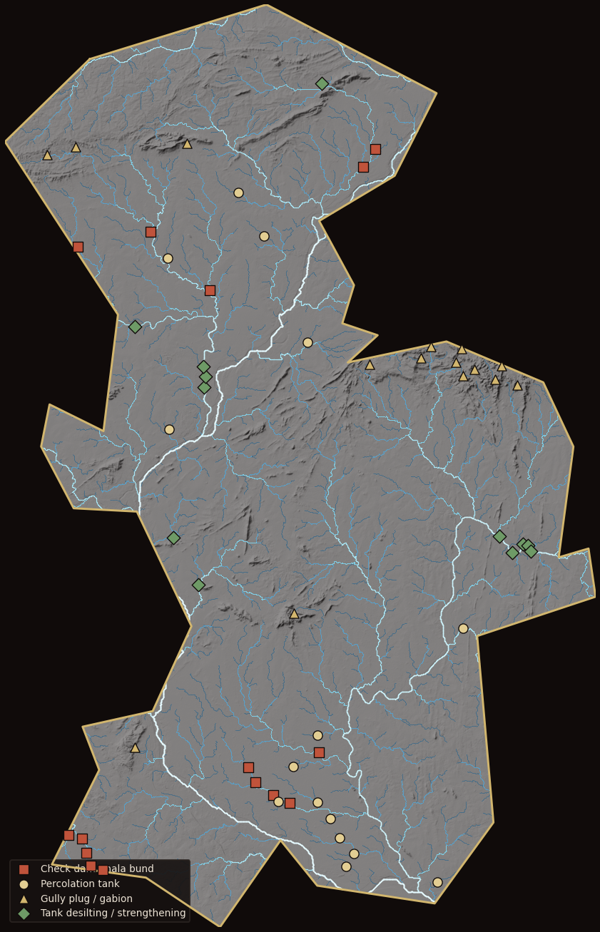
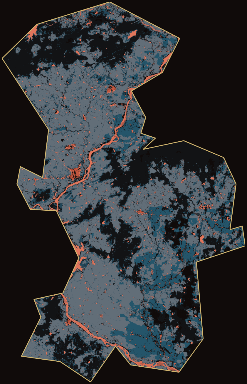
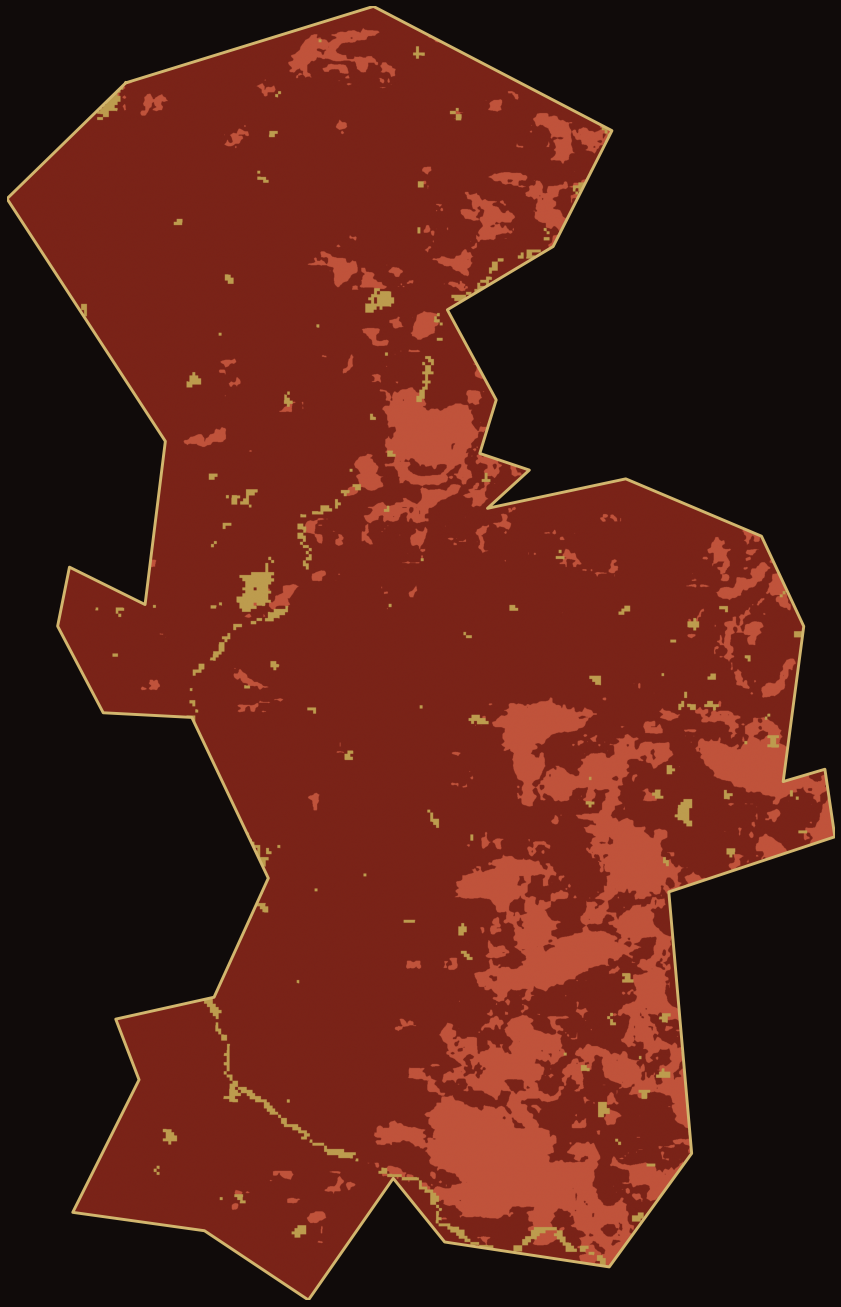
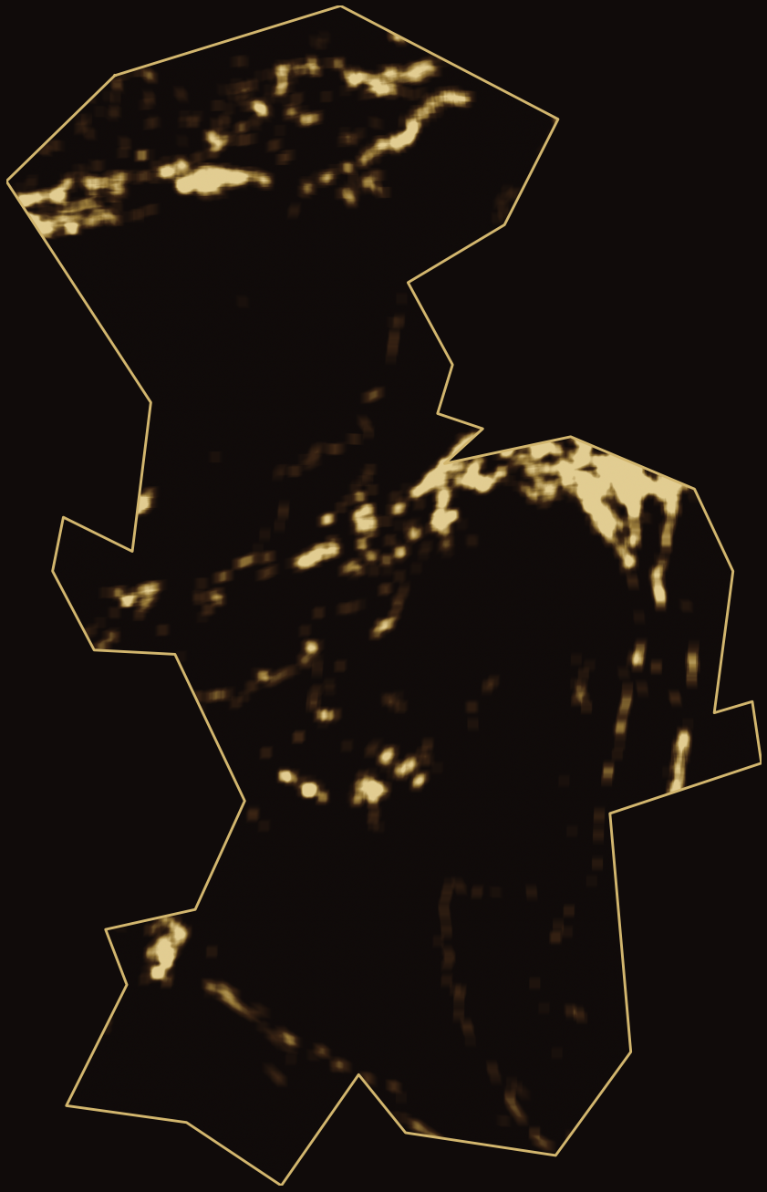
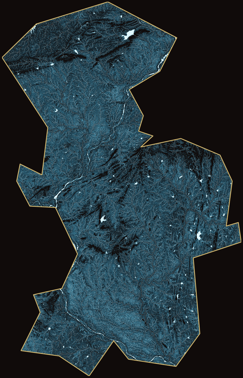
Terrain & drainage
Copernicus GLO-30 hillshade · Strahler-ordered nalas · the sited structures
- 01GLO-30 · WhiteboxTools
Read the terrain
A 30 m elevation model, depression-breached, becomes the district’s full drainage network — every nala ordered 1 to 8, the Wainganga at the top.
- 02AHP · 7 criteria
Site & score
Slope, soil, land use and catchment gate what can be built where; a Saaty-weighted score ranks 57 candidates on the real network — nothing off-channel.
- 03Sentinel-2 + Sentinel-1
Witness from orbit
Four monsoons of optical and radar water extent cross-witness every fill and draw-down — radar sees through the cloud that blinds optical exactly when tanks fill.
- 04Overture · 415,175 buildings
Screen for people
Each design footprint is checked against real buildings; bunds step down to clear settlements, and tank renovations displace no one.
- 05tiers · delta impact
Rank & deliver
Sites resolve into a 11-site shortlist, a worth-surveying tier and the rest — each with the net-new water it would add, counted against its own history.
The evidence
The district, read from terrain up.
A 30 m elevation model, hydrologically conditioned, becomes a full drainage network; land cover and slope gate what can be built where; and a priority score surfaces the sites that fill the real gaps in Bhandara’s tank country. Switch layers, filter by structure, read the coordinates.
Terrain & drainage
Copernicus GLO-30 hillshade · Strahler-ordered stream network · sited structures
Investment shortlist — corroborated & low-displacement
Sites where two independent sensors agree on the water signal (or an inventory lake confirms it) and the design footprint clears existing settlement. These lead; the full roster and its caveats follow below.
near Dhamlewada
restores ≈ 9099 TCM · 1820 ha irrigable · Δ 8645 net-new
near Tekadi
impounds ≈ 235 TCM · 47 ha irrigable
near Opara
impounds ≈ 94 TCM · 19 ha irrigable
near Dongargaon
impounds ≈ 1096 TCM · 219 ha irrigable
near Pimpalgaon
impounds ≈ 248 TCM · 50 ha irrigable
near Gadkumbhali
restores ≈ 1469 TCM · 294 ha irrigable · Δ 804 net-new
near Wadad
restores ≈ 1241 TCM · 248 ha irrigable
near Umari
restores ≈ 2101 TCM · 420 ha irrigable · Δ 1259 net-new
near Umari
restores ≈ 2123 TCM · 425 ha irrigable · Δ 1224 net-new
near Kitadi R
restores ≈ 4196 TCM · 839 ha irrigable
near Kholapur
restores ≈ 2314 TCM · 463 ha irrigable · Δ 2152 net-new
Worth surveying — promising, a blocker or two to resolve
The next tier for the ground team: sites with real water evidence held back by one or two resolvable questions — chiefly land to verify (moderate displacement), a pour-point / through-flow check on the larger nalas, or a signal not yet corroborated by an independent lake. Each still carries its measurable payoff if built. Survey these to promote or drop them.
near Khambata
if built · ≈ 2590 TCM · 518 ha irrigable · Δ 2198 net-new
near Jamni
if built · ≈ 1744 TCM · 349 ha irrigable · Δ 1213 net-new
near Wahani
if built · ≈ 188 TCM · 38 ha irrigable
near Mahalgaon
if built · ≈ 1235 TCM · 247 ha irrigable · Δ 715 net-new
near Hingana
if built · ≈ 158 TCM · 32 ha irrigable
near Kinhi
if built · ≈ 302 TCM · 60 ha irrigable
near Mangli
if built · ≈ 598 TCM · 120 ha irrigable
near Dabha
if built · ≈ 823 TCM · 165 ha irrigable · Δ 665 net-new
near Khamari Bk
if built · ≈ 667 TCM · 134 ha irrigable
near Silegaon
if built · ≈ 158 TCM · 32 ha irrigable
near Panjara
if built · ≈ 225 TCM · 45 ha irrigable
near Chicholi
if built · ≈ 158 TCM · 32 ha irrigable
near Kolari
if built · ≈ 142 TCM · 29 ha irrigable
near Panjarepar
if built · ≈ 143 TCM · 29 ha irrigable
Tank desilting / strengthening · 12
Satellite-observed water bodyRenovate an existing malguzari tank — desilt to restore lost storage.
| Site | Lat, Lon | Water-body area | Catchment km² | Peak water | Confidence | Displacement |
|---|---|---|---|---|---|---|
| tank-5near Dhamlewada | 21.5204, 79.8014 | 284 ha | 65 | 607 ha | high | clear |
| tank-9near Gadkumbhali | 21.0500, 80.0021 | 23 ha | 658 | 98 ha | medium | clear |
| tank-10near Wadad | 21.0334, 80.0165 | 8 ha | 466 | 83 ha | medium | clear |
| tank-6near Umari | 21.0424, 80.0289 | 7 ha | 453 | 140 ha | medium | clear |
| tank-2near Umari | 21.0408, 80.0345 | 5 ha | 452 | 142 ha | medium | clear |
| tank-4near Kitadi R | 20.9975, 79.6692 | 2 ha | 105 | 280 ha | medium | clear |
| tank-12near Kholapur | 21.0462, 79.6407 | 5 ha | 32 | 154 ha | medium | clear |
| tank-7near Jamni | 21.2035, 79.6731 | 17 ha | 757 | 116 ha | low | clear |
| tank-1near Khambata | 21.2144, 79.6752 | 2 ha | 754 | 173 ha | low | clear |
| tank-8near Dabha | 21.2246, 79.6721 | 8 ha | 753 | 55 ha | low | clear |
| tank-11near Mahalgaon | 21.0351, 80.0374 | 2 ha | 439 | 82 ha | low | clear |
| tank-3near Khamari Bk | 21.2660, 79.5963 | 3 ha | 349 | 44 ha | low | clear |
Check dam / nala bund · 15
Sensor-witnessed nala flowNew bund across a 2nd–4th-order nala to hold monsoon flow and recharge upstream.
| Site | Lat, Lon | Priority | Strahler | Slope % | Catchment km² | Peak water | Confidence | Displacement |
|---|---|---|---|---|---|---|---|---|
| cd-1near Kinhi | 20.8237, 79.8038 | 84 | 4 | 2.95 | 133 | 69 ha | medium | moderate |
| cd-3near Chicholi | 21.3645, 79.6123 | 83 | 4 | 2.96 | 69 | 13 ha | medium | moderate |
| cd-11near Kolari | 20.7035, 79.5519 | 83 | 3 | 2.63 | 34 | 6 ha | medium | moderate |
| cd-2near Tekadi | 20.7353, 79.5276 | 83 | 4 | 2.27 | 102 | 4 ha | medium | clear |
| cd-12near Panjarepar | 20.7316, 79.5424 | 83 | 4 | 2.85 | 48 | 2 ha | medium | moderate |
| cd-13near Irali Bk. | 20.7706, 79.7722 | 82 | 4 | 2.50 | 42 | 150 ha | medium | high |
| cd-9near Lawadi | 20.7922, 79.7337 | 81 | 3 | 2.50 | 19 | 66 ha | medium | high |
| cd-8near Mohadi | 21.3046, 79.6785 | 81 | 4 | 2.92 | 68 | 26 ha | medium | high |
| cd-5near Dhamani | 20.7788, 79.7537 | 81 | 4 | 2.43 | 33 | 143 ha | medium | high |
| cd-7near Asgaon | 20.8079, 79.7258 | 81 | 3 | 2.60 | 14 | 92 ha | medium | high |
| cd-14near Silegaon | 21.4343, 79.8481 | 80 | 4 | 1.55 | 116 | 27 ha | medium | moderate |
| cd-15near Wahani | 21.4528, 79.8613 | 80 | 4 | 2.08 | 90 | 114 ha | medium | moderate |
| cd-4near Mendhegaon | 20.7173, 79.5474 | 83 | 3 | 2.87 | 37 | 7 ha | low | moderate |
| cd-10near Bhuyar | 20.6991, 79.5660 | 80 | 3 | 1.90 | 31 | 11 ha | low | moderate |
| cd-6near Ghorpad | 21.3484, 79.5314 | 80 | 3 | 2.16 | 24 | 3 ha | low | moderate |
Percolation tank · 15
Sensor-witnessed nala flowNew pond on a 1st–2nd-order stream to pond runoff and recharge the aquifer.
| Site | Lat, Lon | Priority | Strahler | Slope % | Catchment km² | Peak water | Confidence | Displacement |
|---|---|---|---|---|---|---|---|---|
| pt-9near Dhamani | 20.7721, 79.7590 | 65 | 2 | 0.54 | 5.69 | 124 ha | medium | high |
| pt-4near Gawarala | 20.7051, 79.8350 | 65 | 2 | 2.19 | 7.08 | 69 ha | medium | high |
| pt-10near Opara | 20.7716, 79.8028 | 65 | 1 | 1.49 | 1.54 | 94 ha | medium | low |
| pt-12near Panjara | 21.2509, 79.7877 | 65 | 2 | 1.47 | 7.41 | 20 ha | medium | moderate |
| pt-3near Hingana | 21.4065, 79.7094 | 64 | 2 | 1.49 | 7.94 | 79 ha | medium | moderate |
| pt-13near Khairi | 20.8413, 79.8019 | 64 | 2 | 0.35 | 2.89 | 187 ha | medium | high |
| pt-14near Dongargaon | 20.9542, 79.9629 | 63 | 2 | 0.32 | 7.46 | 43 ha | medium | clear |
| pt-15near Pimpalgaon | 21.3376, 79.6319 | 63 | 2 | 1.73 | 9.84 | 28 ha | medium | low |
| pt-5near Mangli | 21.3614, 79.7385 | 62 | 2 | 1.10 | 5.64 | 59 ha | medium | moderate |
| pt-7near Doke Sarandi | 20.7546, 79.8170 | 66 | 2 | 1.89 | 3.32 | 130 ha | low | moderate |
| pt-6near Kudegaon | 20.7346, 79.8278 | 66 | 2 | 0.22 | 3.39 | 205 ha | low | high |
| pt-8near Bhojapur | 21.1590, 79.6353 | 66 | 2 | 1.60 | 4.46 | 15 ha | low | high |
| pt-11near Dholsar | 20.8086, 79.7754 | 65 | 2 | 2.20 | 3.86 | 71 ha | low | high |
| pt-1near Manded | 20.7185, 79.8432 | 64 | 2 | 0.35 | 3.29 | 148 ha | low | high |
| pt-2near Keshori Kh. | 20.6893, 79.9362 | 64 | 2 | 1.33 | 7.98 | 46 ha | low | moderate |
Gully plug / gabion · 15
Terrain-modelled (sub-pixel)Small check in a headwater ravine to slow erosion and seed recharge — sub-pixel for satellite water.
| Site | Lat, Lon | Priority | Strahler | Slope % | Catchment km² | Peak water | Confidence | Displacement |
|---|---|---|---|---|---|---|---|---|
| gp-8near Khaksi | 20.8273, 79.6000 | 80 | 1 | 5.97 | 1.05 | 2 ha | low | clear |
| gp-1near Bundalghat | 21.2281, 79.8572 | 79 | 1 | 3.97 | 0.59 | 0 ha | low | clear |
| gp-4near Pangadi | 21.2309, 79.9529 | 79 | 1 | 3.78 | 0.71 | 0 ha | low | clear |
| gp-2near Ambagad | 21.4572, 79.6522 | 78 | 1 | 3.84 | 0.91 | 2 ha | low | clear |
| gp-5 | 21.2355, 79.9138 | 78 | 1 | 4.23 | 0.59 | 0 ha | low | clear |
| gp-9near Pangadi | 21.2456, 79.9594 | 78 | 1 | 3.99 | 0.27 | 0 ha | low | clear |
| gp-10near Gidalpar | 21.2277, 80.0035 | 77 | 1 | 4.36 | 0.31 | 0 ha | low | clear |
| gp-11 | 21.2470, 79.9250 | 77 | 1 | 3.97 | 0.63 | 0 ha | low | clear |
| gp-6near Pangadi | 21.2240, 79.9735 | 77 | 1 | 3.99 | 0.37 | 0 ha | low | clear |
| gp-12 | 21.4440, 79.4969 | 77 | 1 | 5.10 | 0.40 | 0 ha | low | clear |
| gp-7near Pitezari | 21.2077, 80.0216 | 77 | 1 | 3.71 | 1.04 | 0 ha | low | clear |
| gp-13near Alesur | 20.9682, 79.7755 | 77 | 1 | 4.36 | 0.69 | 0 ha | low | clear |
| gp-14near Gidalpar | 21.2138, 79.9969 | 75 | 1 | 4.53 | 0.34 | 0 ha | low | clear |
| gp-15near Pangadi | 21.2169, 79.9611 | 75 | 1 | 4.42 | 0.74 | 0 ha | low | clear |
| gp-3near Mandekasa | 21.4524, 79.5281 | 75 | 1 | 4.06 | 0.45 | 2 ha | low | clear |
Method
How it was derived.
Substrate
Copernicus GLO-30 elevation and ESA WorldCover 10 m land cover, plus ISRIC SoilGrids clay/sand (0–30 cm) → Hydrologic Soil Group. Cross-checked against the witnessed MH36 cube for Bhandara (3,631 cells). Reprojected to UTM 44N at 30 m.
Terrain & hydrology
WhiteboxTools: least-cost depression breaching → D8 flow accumulation → Strahler order (1–8, order-8 = the Wainganga), slope, wetness index and drainage density; plus DEM-derived lineament (fracture) density and an SCS Curve-Number runoff surface.
Decision (AHP)
Seven witnessed criteria — runoff, slope, soil, drainage density, lineaments, land use, wetness — weighted by a Saaty pairwise matrix. Because the district is HSG-D clay, two surfaces are built: storage on the runoff-rich lowlands, recharge only where soil is lighter or fractured.
Seasonal witness (radar + optical)
For every site, a four-year (48-month) monthly time series across four monsoons: Sentinel-2 MNDWI (optical) and Sentinel-1 GRD radiometrically calibrated to σ⁰ (DN²/sigmaNought² from the product calibration LUT, GCP thin-plate-spline geocoded), open water at σ⁰ < −17 dB. Four monsoons capture inter-annual variability — how a tank behaves in a deficit year, not just one snapshot. Radar sees through the monsoon cloud that blinds optical exactly when tanks fill — the two sensors cross-witness each fill and draw-down.
AHP criteria weights
Consistency ratio 0.003 (< 0.10 = consistent)
What this is — and is not
- · Every site is cross-witnessed — optical (S2 MNDWI) vs radiometrically calibrated radar (S1 σ⁰, water at < −17 dB) water agreement, and an independent HydroLAKES check. Each carries a confidence grade; new structures are capped at medium (no ground truth a new reservoir will hold) and low-confidence sites must be ground-truthed before any funds are committed.
- · A 30 m regional screening that narrows ~163,000 stream cells to a shortlist — not an engineering survey. Every new structure is checked for displacement against real building footprints (Overture: OSM + Google + Microsoft, 415,175 in the district) inside its design-bund submergence — stepped down from 3 m to 2 m where a full bund would flood a settlement; tank renovations acquire no new land. This precedes — not replaces — a cadastral (7/12) overlay and ground survey before sanction.
- · Reconnaissance context is from map APIs — Ola Maps + Google Places give the nearest habitation, landmark and benefit amenities (schools/health) per site, a second independent witness to displacement. They do not provide cadastral land records, geotechnical bores or level surveys — those remain a statutory ground task.
- · Groundwater decline is not yet fused — the WRIS telemetric feed has no Maharashtra coverage, so we did not fabricate a recharge-need layer; CGWB seasonal (pre/post-monsoon) levels are the next join.
- · Lineaments are DEM-derived structural proxies (automated Hough extraction), indicative of fracture zones — not a surveyed GSI fracture map.
- · The radar record is single-satellite before Dec 2024 — Sentinel-1B was lost in Dec 2021 and S1C only came online Dec 2024, so most of the 48-month window is S1A alone (12-day repeat). Monthly compositing absorbs this, but the earlier years have fewer candidate radar passes than the optical record (Sentinel-2, 2017–).
- · Boundary is geoBoundaries ADM2 (4,223 km²); the LGD-2011 record is 3,717 km² — a boundary-vintage delta, not an error.
Provenance
- DEM
- Copernicus GLO-30 (ESA) tiles N20/N21 x E079/E080
- Soil
- ISRIC SoilGrids v2.0 clay & sand 0-30 cm (/vsicurl)
- Land cover
- ESA WorldCover 10 m v200 (2021)
- Hydrology
- WhiteboxTools: breach_depressions_least_cost, d8_flow_accumulation, strahler_stream_order, slope, wetness_index
- Lineaments
- DEM multi-azimuth hillshade -> Canny -> probabilistic Hough (skimage)
- Boundary
- geoBoundaries ADM2 Bhandara (4,223 km2; LGD-2011 = 3,717 km2, boundary-vintage delta)
- Cube cross-check
- s3://gg-ananda-prithvi-pristine/derived/bharata_strata/sprint-6/mh36-unified-v1/admin_code=471
DEM tile fingerprints (SHA-256 · 16)
- N20_00_E079.tif29db2e4f070afc0f
- N20_00_E080.tif53d7465f3a735ce3
- N21_00_E079.tif3c16332fc0ad8904
- N21_00_E080.tif54aa601652335ffb
Generated 2026-07-02 · reproducible from scripts/water/